In addition to lighthouses, over the years other navigational aids helped guide and protect sailors using the Cape Fear River.
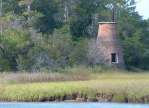 Range Lights. This unique system used a pair of lights with a shorter one in front of a taller light. By positioning the taller light directly above the shorter one, the mariners knew they were in the center of the channel. The Prices Creek Range Light, commissioned in 1848 and long since abandoned, still stands near the Southport ferry terminal.
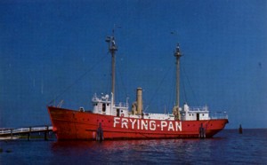 Lightships. From 1854 until 1966, various sail and diesel powered ships were anchored off the tip of Frying Pan Shoals, the silt-formed underwater extension of the Cape Fear River stretching some 28 miles into the Atlantic Ocean. These lightships assisted lighthouses in warning mariners of the dangerous, ever-shifting sandy menaces to navigation.
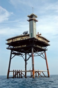 Light Tower. Sometimes referred to as a Texas Tower due to its similarity to oil drilling platforms found in the Lone Star state, this massive four-legged platform (located approximately 28 miles south of Southport) stood 130 feet tall with steel pilings driven 293 feet below the ocean floor. Replacing lightships beginning in 1966, the tower was originally manned by a Coast Guard crew of six. The lights – visible for 17 miles – were automated in 1979, then the tower was deactivated as a navigational aid in 2003. The Frying Pan Light Tower was sold at auction by the federal government in 2010 for $85,000 and is now operated as a bed and breakfast.
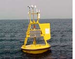 Buoy. Since 2003 the National Oceanic and Atmospheric Administration has marked Frying Pan Shoals with a 3-meter discus buoy (NDBC Station 41013) employing a meteorological payload. The buoy is located about 8.22 miles southwest of the existing Frying Pan Shoals Light Tower.